SACRED ISLAND
A BUDDHIST PILGRIM'S GUIDE TO SRI LANKA
compiled and edited by Ven. S. Dhammika
SACRED PLACES
Arankale
Nothing is known about the history of Arankale other than it was a monastery of the Pansakulika sect, not even its ancient name is remembered. The name Arankale is probably derived from arahan, an enlightened one, and kale, a forest. The ruins are nestled in thick jungle at the foot of the thickly forested and rather forbidding looking Dolukanda. This mountain is mentioned in the Mahavamsa as having once been the base of Silameghavanna just before he was defeated by King Moggallana III. Records also speak of King Kirti Sri Rajasingha having attended a temple ceremony at a temple near Dolukanda but this could not have been Arankale as this was totally covered in jungle at that time.

The Mahiyangana Stupa
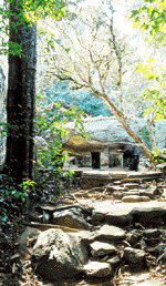
The pilgrim gets to the ruins by passing through a modern meditation monastery. Ask one of the monks and he will show the path. Soon the pilgrim will come to a large rock with a monastery built under it. Turning right from here the path leads to a large oblong boulder with many mortous holes in it showing that several structures were built against or under it over the centuries. Local legend says that this is where the arahat Maliadeva once lived. To the left of the cave a rough track through the jungle leads to the ancient monastery’s main path. This is the longest and most impressive such path found in any of the Pansakulika monasteries. It runs for about a quarter of a kilometer and is raised as much as 5 feet off the ground for much of its course. What could this very substantial elevated path have been used for? About a third of the way along is a roundabout and further still a side path with stairs leading to some double platforms. All Arankale’s caves and double platforms, about 20 altogether, are on the hillside to the left of the path. The path eventually ends in a T intersection. The stairs to the left lead to a series of double platforms some of which are built on natural rock foundations. Return to the intersection and continue walking towards the monastery’s main buildings.
On the right of the path is a small building which would have served well as an image house although no image was found here. Beyond this is the monastery’s main bathing place, a large rectangular reservoir with steps on all sides leading down to the water. Locals still bathe here and it can be a good place to have a cooling swim.Directly facing the end of the path is what was probably the sima.
It is built in the center of a large square depression with the natural rock forming its bottom. Was this depression originally meant to be filled with water? To the left of the sima is another interesting structure with a gently curving path leading to it. This building was a promenade (cakmana) for walking meditation and probably originally had a roof over it. Note the two toilets on the south side. A path behind the promenade leads to the refectory. The impressively solid walls of this building would almost make one think it was a prison rather than a place where monks were fed. Note the sunken and paved courtyard and the grindstones.
How To Get There
Arankale is 25 kilometres from Kurunagala via the village of Ibbagamuva.
© 2007 Copyright Ven. S. Dhammika & BuddhaNet/Buddha Dharma Education Association Inc.

